56 miles today.
Last night we got in much later than we had planned. Instead of arriving in Leesburg around dinner time, we arrived after dark. We both had our headlights and bright taillights working as we crossed the Potomac on White’s Ferry. We made our way up to route 15 and followed it in towards Leesburg. There was a very wide shoulder so it felt pretty safe … but then the shoulder disappeared! The traffic was going about 60+ MPH and I said to Joe “No way!” We needed to find another route.
Living in the digital age is pretty handy some days. We pulled out our phones and researched the streets. Joe noted that if we backtracked, there was a route that took a couple of extra miles, but looked OK. I put our AirBNB address into my Garmin Edge cycling GPS and like magic, it routed us back and roughly the same way Joe was pointing out.
As we turned onto the quiet country roads, the sun went down. Thank goodness for a strong headlight and a trusty GPS. The GPS brought us to a gate of Morven Park. It was locked. We were stressed, it was dark. We decided that trespassing was warranted. We took our bikes around the gates and cycled through the park streets. We had to exit the other side around another set of locked gates. But our little, um, maneuver took us to a very safe set of roads right to the door of our B&B. Whew. Felt good to be off the roads.


Here’s the very cute B&B we stayed in right as we left this morning. I really liked it. It was like the original Tiny House, built in 1841.

Breakfast was a good omelette. Fuel for the ride.

We returned via the same Morven Park route today. Only the park was open this time, so we didn’t break any laws getting through. Morven Park is some sort of equestrian park, like the Kentucky Horse Park. It was very pretty and made for an awesome start to the day’s ride.

Then, back over the ferry from VA to WV:

The C&O is a pretty rough trail. It varies a little in condition, but most of it looks like this:

There is a lot of mud, many puddles, ruts, and squishy sections. On an normal road ride, I average around 16-17 MPH. On the C&O, I average around 11-12 MPH for the same physical effort. The surface just sucks the energy out of you.
In several places along the canal there are Lock Houses. These are the original residences of the families that would operate the locks. Some of them can be rented for staying over. They are primitive – no water or electric.

We crossed a number of aqueducts. These are bridges that used to carry the canal water over the creeks that feed the Potomac. Several have been restored, but none of them carry water any more. You can ride through the trough of the aqueduct or walk your bike along the old mule path on the side.


I had a mishap today. When we were riding along there was a short wooden bridge. The front edge was above the trail by about an inch or two. When my front wheel hit the edge, it popped up. The deck of the bridge was very slick and when my tire came down, it slid out from under me and I went down hard. I only have a couple of bruises to show for it, but my rear fender snapped in two and my front fender got pretty banged up too. It could have been much worse.
For lunch we decided to pop into the town of Brunswick MD. We found Beans in the Belfry and got a little to eat. I wasn’t hungry yet, so I just had some really yummy hummus and warm pitas.


When we got to Harpers Ferry WV, we decided to walk over the bridge and take a few pictures. We didn’t spend any time in the town this time – we’ve stayed here before. Instead, we wanted to save our time to spend at Antietam battle field.
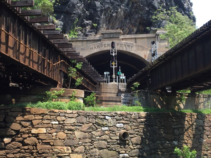


Harpers Ferry is at the confluence of the Potomac and Shenandoah rivers. You have to cross over on a foot bridge from the C&O to the town. It’s a really neat walk over the bridge. But note that if you want to bring your bike across, you have to climb 50+ stairs with your equipment before crossing! We did that before, but this time we decided just to leave our bikes behind.
Back on the trail, we kept on pedaling along.

We still wanted to get to Antietam. Joe is a Civil War buff and this was high on his list. But there was one catch: my GPS unit kept warning me about severe thunder storms approaching. We decided to get to the bridge to Shepherdstown and then decide whether to visit tonight or try in the morning tomorrow.
To get to Shepherdstown, you have to climb a set of switchbacks up to the bridge level. To go to Antietam, you go about 6 miles NW. We looked at the weather and it said we had about 2 hours before the storms would hit. So… we made paces to get to the battlefield.
I have not studied much about the Civil War in the past, but I knew a bit about Antietam. It was powerful to think about the thousands of men who died that day and realize that I was standing where so many people died.
It is also kind of surreal: it is so beautiful and peaceful up here. But the amount of death unleashed that day was incredible.


This is the restored Dunker Church, a focal point of the battle. It was destroyed by wind in the 1920s but was reconstructed in the same place. The place where I am standing is where Abraham Lincoln stood at one point.
Right after that picture, we started to hear thunder. It was time to go. It is too bad, there were a couple of more places I’d have liked to see… but when the GPS keeps saying “SEVERE THUNDER STORM WARNING”, you have to pay attention.
We made very good time heading about 6.5 miles back to the bridge and up to our hotel in Shepherdstown WV. As we pulled into the hotel, a couple of raindrops hit. Then as we were under the carport by the front door, the skies opened and the rains came down in buckets. Wow. Perfect timing! I credit my wife who was watching our progress on the internet and praying hard for us to be safe from the weather. Thanks, Steph!
Even though we didn’t get rained on during the ride, the C&O provides a lot of opportunity to get wet, muddy, and dirty. Here’s what my legs looked like when I took my sock off. Yuck.

After a shower with LOTS of soap and water, we went in search of dinner. Both Joe and I have been hankering for Chinese food. During a break in the rain, we walked next door to the shopping plaza to pick up some Chinese food and brought it back to the hotel. Shrimp with mixed vegetables and rice. Mmmmm….

Tomorrow we head to Hancock MD. We only have one side-trip planned to Fort Frederick. Other than that, it should be a straightforward day of 55 miles. We’re hoping that the rain stops and that the path isn’t too muddy from the rains tonight. I’m expecting to be very muddy tomorrow.
Time for bed. Peace!
