
It was wonderful to have Stephanie and Maura meet me last night. We had a room at the Embassy Suites in Independence OH. Rockside Road goes right from the bike path trailhead to the side road where the hotel is located. There is a sidewalk on the south side of Rockside Rd. that you can take the whole way up.
We had a nice dinner and turned in for the evening. I got up early in the morning so I could complete my ride and give us plenty of time to drive home.
Today’s trip was very short – only sixteen miles. I could have easily put these miles in yesterday and finished up yesterday, but I wanted to arrive in Cleveland during the quieter traffic hours of the weekend instead of during rush hour on Friday.
I packed up my things and loaded the bike back up. I felt the strong need to carry all of my things with me instead of just dumping them in the car, so I carried everything that I brought on the trip with me as I completed the journey. I guess it felt to me like I needed to finish the whole trip self-supported. So my panniers went with me.

Leaving the hotel parking lot, I could make out downtown looking north. The construction porta-potty is just a nice backdrop, not the subject of my picture… You can see the skyline off in the distance.

The air felt absolutely amazing this morning. It was cool and crisp. I needed a light jacket for the first few miles. A very slight breeze was blowing. It felt and smelled like fall is coming. What a stark contrast to a week ago where the sun was beating down upon me with high in the mid 90s. I love this kind of weather.
After riding about a mile east on Rockside Road using the sidewalk, I rejoined the canal path heading north towards the city. The path winds through some very nice parks and the outskirts of downtown Cleveland. As you get closer to downtown the heavy industrial areas emerge.


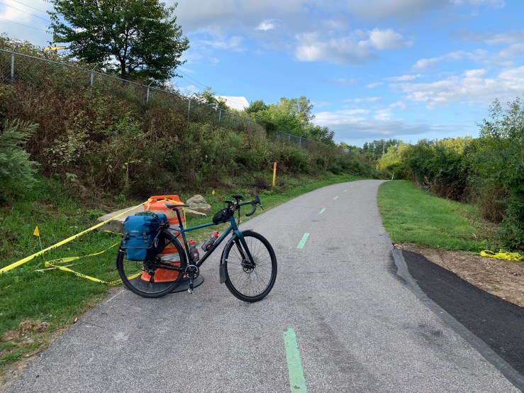
The towpath ends unceremoniously at Harvard road. The last time I was here, there was a very small trailhead. It was under reconstruction when I arrived yesterday and the signage was gone. I assume they’ll bring it back when the trailhead is finished. Here’s about where the sign used to be:
I had been warned that the path through Cleveland was disrupted with construction, but I did not have any trouble at all. I’ll have a brief description and map of my route at the end of the blog today.
Steelyard Commons is a shopping center built on the site of a former steel mill. This is a rail car that was used to haul molten steel to different parts of the manufacturing process. The tank of the car is lined with bricks to provide insulation for the molten steel.

Leaving the Steelyard Commons I followed the towpath up the hill west for a block to the 14th street roundabout. From there I took 14th street northbound with only a small side trip.
The house from “A Christmas Story” is very close to the route. It wasn’t open yet so I just took grabbed a picture and resumed my route. The house is only a block or two out of the way off of 14th street, so why not?


Returning to 14th street, I continued north all the way towards downtown.

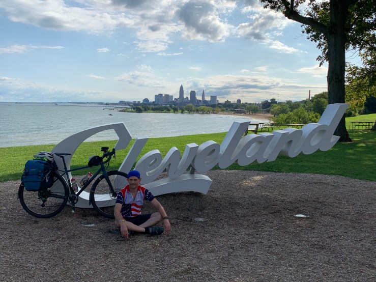
14th street ends at Abbey Avenue. One of the Cleveland script signs is in a small park at this intersection, so that’s a good landmark and seemed like a great place to take a picture overlooking downtown. There are several of these script signs around the city and they all provide a good photo opportunity. I found two of them on my route.

About 100 yards east of here, there is a new bike trail that takes you along the edge of downtown and westward. When you get to the end of the trail, it is an easy ride west on Franklin Road and then Franklin Avenue to get to 65th street.

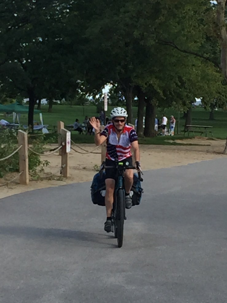
Taking 65th street north to the end puts you at the lakefront. A nice bike path winds through Edgewater park. The path goes along the lakefront to the beach area. I decided that this is where I would dip my tires into Lake Erie! To my very pleasant surprise, Stephanie and Maura were waiting for me at the beach and caught a picture of me.

Here I am at Lake Erie! It’s official – I’ve crossed the state, dipping my tires in both the Ohio River in Cincinnati and Lake Erie in Cleveland.

I wanted to finish at the Cleveland sign in Edgewater Park. We didn’t see it anywhere so I asked and some people who pointed me up a path west of the beach. I jumped on the bike and rode up to the top of the path. Here it is… the end of the journey!
I was very pleased to have both Mr. Hamster, the international traveler, and Ms. Bug, the new member of my riding team, along for the last 16 miles.

Today was a fantastic end to a wonderful journey. The short trip today felt a bit like a victory lap since it was such an easy ride. It was definitely fun and Cleveland has some nice bike paths!
After getting the last pictures at Lake Erie, we loaded up my bike and I changed into regular clothes. We drove home at a very nice leisurely pace, stopping by Canal Fulton for lunch and Massillon to show the church and shrine to Stephanie and Maura. After a few more stops, we made it home late in the evening.
This morning felt very strange. I felt like I was supposed to be out riding. It feels odd not to be heading somewhere on the bike. I think it will take a couple of days to get back into the normal rhythm of life.
My grand total milage for the trip is exactly 450.00 miles. I found it amazing that it was exactly 450 miles according to my GPS logs. I will have one more blog post in a few days with some lessons learned, a few thoughts on the trip, and a gear review of my bike and other equipment.
Thank you to all who have sent me words of encouragement along the way. It has been great to share my trip with you. Thank you especially to those who gave me a place to sleep on my trip. I appreciate you kindness.
Below is a description of my path through downtown Cleveland if you’re reading and preparing for your own OH2ERIE trip.
St. Dymphna, Pray for us!
Peace.


Navigating to Lake Erie / Edgewater Park from the Towpath:
This is my GPS track from my ride yesterday.
- When completing the towpath, exit onto Harvard Road. Turn Left (W).
- Cross the railroad tracks and turn right on the path which parallels Jennings Road (N). This path will veer to the right and go behind Steelyard Commons.
- Continue behind Steelyard Commons to where the path goes under Quigley Ave. It will curve to the right and back westbound as you parallel Quigley Ave.
- Quigley Ave ends at 14th street. Turn right (N) onto 14th street.
- Travel north on 14th street until it ends. Near the end it will veer to the left under interstate 90 / 71. 14th street will end at Abbey Avenue.
- At the Abbey Ave / 14th intersection is one of the “Cleveland Signs”. On the north side of Abbey Ave, go right (east) about 100 yards to pick up a the bike path. It will circle back to the left and take you along the river.
- At the end of the bike path, turn left (S) onto Columbus Road and take an immediate right onto Franklin Avenue.
- Take Franklin Avenue to the end, and turn left (S) onto 25th street for one block.
- Turn Right (west) onto Franklin Blvd.
- Turn Right (North) onto W65th Street. This will take you to Edgewater Park
- Follow the bike path into the park. The trail will eventually lead you to the beach.
- If you want to go to the Cleveland sign, continue past the beach up the hill to the west. The sign will be at the west end of Upper Edgewater park.

